London Bus by Zuti app for iPhone and iPad
4.2 (
3152 ratings )
Travel
Navigation
Developer:
Visual IT Ltd
Free
Current version:
4.0, last update: 6 years ago
First release : 23 Apr 2010
App size: 74.27 Mb
Now travelling by bus in London has never been easier!
● Fast, simple and intuitive to use.
● Works anywhere, including on a plane, underground and with data roaming turned off.
● Live bus countdown information (internet required).
● The only bus app with a inbuilt bus map.
● Lists every street in 450 square miles.
● Map and routing data are all stored on the device.
● Animates the route and allows tracking of the journey using GPS.
● No waiting for an internet connection.
● Saves battery power and roaming charges.
● Streets, Places of interest etc built into the application.
● OVERVIEW
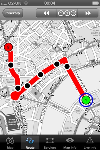
The new London bus application makes it easy to travel in and around the city by bus. Unlike old fashioned schematic style maps this product contains a geographically accurate map showing streets, parks and places of interest etc.
● MAP
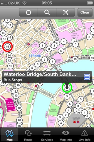
The map is hand drawn by Visual IT and provides a unique geographically based view of London bus routes covering 450 square miles so you can easily get your bearings when travelling around the city. You can also use your inbuilt GPS to accurately locate and track yourself and see the nearest transportation stop and distance to it. This is the only public transportation route planner with this ability.
Tap on the map for location information, use the inbuilt search feature or choose from a list of locations. Places of interest, museums, hotels, parks, restaurant, shops, hospitals, streets, etc, are also included. The route planner will automatically suggest the nearest stop to any place of interest you select.
Now with the ability to place markers, routes and areas of interest directly on the map for future reference.
● MINUTE MAP
Another unique feature is the “Minute Map” option which allows you to see the travel times from a start point to all other locations on the map. This is a great way to view the topology of a city and gauge travelling times.
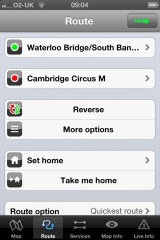
● ROUTING
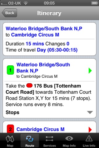
The application does not require an internet connection and will always be available to display a clear and detailed view of the bus routes, plus list and animate the optimum route for your journey. This product provides the fastest route calculations of any mobile routing application using actual published journey times with the ability to select the quickest route or the route with the least changes.
● LIVE INFO
When an internet connection is available, optional "Live Information" on the current state of the transport services can be viewed allowing you to plan your journeys in advance and avoid any potential delays. Unique to this application is the ability to turn off services that are out of action and automatically calculate an alternative route.
● LIVE BUS DEPARTURES
Also included is the ability to view live bus departure (data supplied by TFL) for any of the bus stops supporting this data feed.
● MORE MAPS
This map is one in a series of Zuti worldwide city maps, if you like this product you may also enjoy some of our other offerings, please visit www.zuti.co.uk for further information.
Pros and cons of London Bus by Zuti app for iPhone and iPad
London Bus by Zuti app good for
Wonderful app, with all information you could dream of: a map with GPS, a calculator to find out the routes from any place (not necessarily a stop) to any other... By taping on a bus stop on the map, you see the list of bus services from that stop in the relevant directions and you can highlight the route of any of them for a better understanding. The app also tells the frequencies of every service, day or night.
It´s a must-have that will make you not take the subway any more.
I liked so much this one for 5,49€ good price u can fine everythinks what u want postcode and streets and museums.
We were tourists in London and used underground and bus transit. This app was a great help during our visit, since in many cases if we had the time we would take bus routes instead of underground so we could see more of the city.
Pros:
Turn on location to find out where you were.
Shows nearest bus stop
Shows bus services including time between buses
We would choose where we were going to, then find out how long it would take by bus. (In many cases we would use the subways map to find similar travel time and decide then if we wanted to save time by underground, or see more of the city using a bus. It probably meant we used busses much more than we would have otherwise, since in many cases the times werent too different.)
And, does this all offline!
Cons:
The app takes a bit of time to figure out. Once you do its trivial.
The map isnt fully detailed, missing minor street names. Not a big deal to me, since I also had a highly detailed offline map app that also had wiki articles on many of the sites around us. Ill give it 5 stars since I cant choose 4.75.
Summary
Great app for London tourist, along with the related underground app from the same company.
This company is my first choice for transit maps for any other cities I visit. Am currently using their paris metro map, but didnt see a Paris bus map.
Fantastically useful app! Works offline, and includes street map with bus stand positions nicely laid out. Relied on it exclusively for all bus information during recent visit to London. Planned with it ahead of time, and used it to change plans in real time. Worked perfectly, except for one bus change at Euston station (going from British Museum to Madam Tussauds) that I just couldnt figure out.
I used this on a recent vacation in London and found it reliable. The ability to use it in airplane mode without communications charges makes it very helpful for American visitors.
Fantastically useful app! Works offline, and includes street map with bus stand positions nicely laid out. Relied on it exclusively for all bus information during recent visit to London. Planned with it ahead of time, and used it to change plans in real time. Worked perfectly, except for one bus change at Euston station (going from British Museum to Madam Tussauds) that I just couldnt figure out.
Some bad moments
App isnt usefull
Bus routes to from London Heathrow Airport are not listed
Used to be great app but the last three times I tried to use it the bus routes were wrontpg-Im assuming they were correct once but are now out of date
Refund please! The station I use most, in Peckham, can neither be used as start or end of my journey. Therefor this app is useless for me.
Since upgrading to iOS9 and iphone6s, after a route is selected, no further information is provided when tapping on a stop or any other place on the map.
Usually London Bus by Zuti iOS app used & searched for
tfl,
rail planner app,
oyster,
rail planner,
tfl pro,
metro and bus,
tfl oyster,
travel and transport,
bus map,
map it,
bus checker,
oyster.com,
and other. So, download free London Bus by Zuti .ipa to run this nice iOS application on iPhone and iPad.